West Nile virus activity in San Gabriel Valley
.jpg?ixlib=rb-1.1.0&w=2000&h=2000&fit=max&or=0&s=d1666e2dc5d0cea8b31a16798f0d5345)
Last update: 2026/07/20
Our agency reports data related to mosquitoes. Human cases are reported by the L.A. County Department of Public Health and Pasadena Health Department.
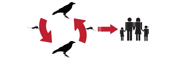
The San Gabriel Valley Mosquito & Vector Control District has been tracking West Nile virus activity in mosquito populations since 2003. Dead bird data is stored with the California Department of Public Health. You can access the dead bird data HERE.
West Nile virus Facts
- West Nile virus is the most common mosquito-borne disease that affects residents in Los Angeles County
- Public health agencies detect West Nile virus every year in L.A. County. This means the virus is found naturally in our city environments, which means it's endemic.
- Our agency uses routine traps to collect samples of mosquitoes. The mosquito samples are tested for mosquito-borne diseases, such as West Nile virus. In addition, dead birds, which can carry West Nile virus, are submitted for testing.
Year-to-Date Statistics for 2026
2026 WNV+ Mosquito Samples
A sample is a random collection of 10-50 mosquitoes from a trap. Positive mosquito samples from routine and randomized trapping provide insight into the spread of West Nile virus.
| City/Community | Date of First Detection | Positives |
|---|---|---|
| Azusa | 2026/07/15 | 1 |
| Pomona | 2026/07/14 | 1 |
| Covina | 2026/07/15 | 1 |
| West Covina | 2026/07/08 | 2 |
| Baldwin Park | 2026/07/08 | 1 |
| La Puente | 2026/07/08 | 1 |
| Rosemead | 2026/06/30 | 1 |
| Alhambra | 2026/06/23 | 1 |
| Total # of Positive Mosquito Samples this Year | 9 |
2026 WNV+ Dead Birds
People report dead birds they observe in their community. Positive dead birds are an indication West Nile virus is widespread in the region.
No Detections at this Time
Take a look at mosquito disease activity throughout California using the VectorSurv Map!
To experience the entire site, visit: VectorSurv.org
.png?ixlib=rb-1.1.0&or=0&w=720&h=720&fit=max&auto=format%2Ccompress&s=0554c4b6ae8fe710c683720da4be53a3)